REVEAL

for Resources

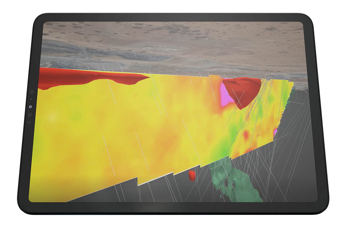
Develop a detailed understanding of an identified ore body, improving and reconciling model accuracy quicker with less in-fill drilling.

Improve resource modelling with high-resolution 3D density models of the ore body, with minimal drilling.

Resolve density variability across the resource, reducing discrepancies between planned and actual recovery.

Reduce economic uncertainty with more reliable tonnage forecasts and optimized mine planning.

Drill less. Recover more. Faster.

  • “Validated against known geology, muon tomography is an effective tool for subsurface density characterization. This broad-scale, high-resolution visibility allows us to operate more cost-effectively and decrease our exploration footprint.”
    Jack Milton, Ph.D.
    VP Exploration at Fireweed Metals

With 400 m drill hole spacing, Ideon can deliver insights typically seen from 50 m spacing.

Ideon’s high-resolution imaging solutions and AI tools enable miners to move quickly from identifying an orebody to understanding what resource is available.

REVEAL™ for Resources can dramatically reduce the need for in-fill delineation drilling, improve ore recovery outcomes, and accelerate time to market for the metals produced – ultimately saving millions of dollars and reducing planning risk.

Gain an unmatched understanding of your resource, de-risking operations and unlocking economic value:

Reduce drilling by >40% 

Build a detailed understanding of the resource with wide drill spacing, focusing drill activity on validation rather than delineation.

Reduce time to understanding by >30%

Accelerate recovery with improved model accuracy, and confidently inform mine planning decisions.

Unlock millions in value

Develop a precise understanding of tonnage to be mined, hauled, and processed, resulting in a more accurate production forecast and greater economic confidence in the resource available.

The accuracy of resource knowledge directly impacts the time and cost it takes to get metals to market.

Resource characterization and modelling provide detailed information about the quality and quantity of mineral resources available in a mining project. It involves estimating the size, shape, and distribution of mineral resources within a deposit using mathematical and statistical techniques based on a variety of data sources. Accurate modelling directly informs decisions about mine planning and operations. It also helps mining companies move from understanding inferred and indicated resources (the concentration of material of economic interest) to documenting reserves (the parts of the resource that can be economically mined). 

Determining geological characteristics of a mineral resource is complex.

Throughout the mining lifecycle, resource modeling underpins critical mine decisions. Resource geologists gather and leverage any available geoscience date sets, including government surveys and maps, drill core samples, satellite imagery, and various geophysical data to generate a 3D block model of the mineral deposit – which is then used to estimate the mineral resources, plan mining operations, and make strategic decisions as production advances.  

Resource modelling experts encounter challenges in gathering, understanding, and optimizing large, multi-faceted datasets – and then accounting for the underlying variables and inherent uncertainties. The accuracy of that model informs logistics, hauling, and processing planning based on an understanding of the tonnage to be mined. Improvements in that accuracy – attempts to reduce remaining geological uncertainty – are often pursued through delineation drilling in increasing smaller grid spacing.